Berlin Wall Trail - From Schönefeld to Lichtenrade

A map display follows. Skip map

MAP loading ...

End of map.

Link zeigt: Orte-Markierungen Former border crossings

Link zeigt: Orte-Markierungen Museums and exhibitions

Link zeigt: Orte-Markierungen Memorials

Link zeigt: Orte-Markierungen Artistic markers

Link zeigt: Orte-Markierungen Memorial sites for the victims of the Berlin Wall

Link zeigt: Orte-Markierungen Commemorative sites

Link zeigt: Orte-Markierungen Remains of the Wall

Link zeigt: Orte-Markierungen Historical information

Link zeigt: Orte-Markierungen Places of interest

Link zeigt: Orte-Markierungen Other key sites

The former border patrol road used by GDR border guards

Much of this tour takes you along the city’s edge through the undeveloped landscape of southern Berlin. The former border patrol road used by GDR border guards has been partially preserved here, as are some of the floodlights that lit up the border strip at night. At “Dörferblick,” a grassed-over former garbage dump almost 90 meters high, the GDR border took a sharp turn to the north, towards the panorama view of Gropiusstadt and a spot that – from 1973 to 1977 – was once a hole in the Wall. A makeshift crossing into the GDR had been set up for garbage trucks at Kölner Damm. Trucks belonging to West Berlin’s city cleaning company drove from here along a fenced-in road to the household garbage dump Grossziethen. Today a Berlin Wall Trail info board marks the entrance to the dump, where 4.4 million tons of garbage were unloaded over four years. As a city with no surrounding countryside, West Berlin had little space for garbage dumps of its own, making it dependent on long-term waste disposal contracts with the GDR during the years of division. These contracts were renewed after 1990 as agreements with the federal state of Brandenburg. Starting in 1997, the railway company Neukölln-Mittenwalder-Eisenbahn transported construction rubble and excavated earth from construction sites at Potsdamer Platz to Grossziethen. It was used to fill in and prepare this refuse site for its new use as a recreation area.

Memorial marker recalls the “peaceful opening of the border”

Near Kölner Damm, you will see a memorial for Eberhard Schulz, who was 20 years old when he was shot here by GDR border guards in 1966. From Lipschitzallee, take Ringslebenstrasse to Buckower Damm, where a memorial marker recalls the “peaceful opening of the border” between Grossziethen and Berlin-Buckow. Borough representatives from Neukölln celebrated the tenth anniversary of this event by installing this memorial on 2 January 2000, a day on which “representatives from Neukölln and Grossziethen and witnesses to the opening of the Wall came together to commemorate this great event in history.” If you look at a city map, you will see that Buckow and Grossziethen are actually built up as a single unit, which makes a memorial at this site all the more logical.

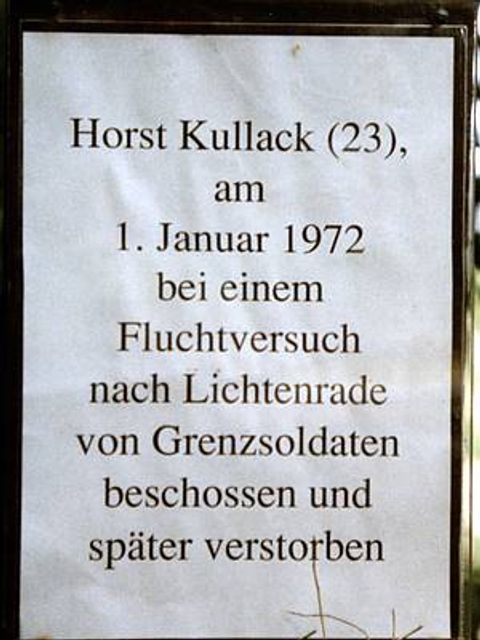
Gedenktafel Kullack

Info Marker for Horst Kullack

Near Rathenower Strasse, the Wall’s course turns to the south along Töpchiner Weg. Taking Strasse 9 to return to the border strip, you will see an info marker for Horst Kullack on the former border strip and a memorial cross near Wittelsbacher Strasse, which was put up in West Berlin long before the fall of the Wall. At the age of 23, Horst Kullack was shot without warning during an escape attempt on 31 December 1971. Three weeks later, after several operations, he died of his injuries in a hospital on 21 January 1972.

Berlin Wall Trail near Großziethen

The Mahlow border crossing was opened in 1977 on Kirchhainer Damm (B96), which you will cross before turning towards the Lichtenrade S-Bahn station. Trucks transporting municipal waste and construction rubble from West Berlin came through here regularly on their way to the Schöneiche refuse site, along with trucks bringing building materials to West Berlin. Passenger traffic related to the garbage dump was also permitted to cross here. A tunnel was built under the B96 highway for the GDR border guards. Nearby you will find an info marker for another victim of the Wall, Herbert Kiebler. On the evening of 26 July 1966, Eduard Wroblewski was killed in a hail of bullets by GDR border guards, while trying to reach West Berlin. Thirty-three at the time, he was shot near the railroad tracks, which were no longer being used. A memorial was dedicated to him in 2009 at the Mahlower Grenzgraben near Paplitzer Strasse.

About the route: This section of the Wall Trail is 16 kilometers long, making it best suited for cyclists. If you would like to break your tour along the way, you can shorten the trip by about a third by turning off to the Lipschitzallee subway station. Unfortunately, you will need to make a wide detour around the border strip between Schönefelder Strasse and Kleinziethener Weg at “Dörferblick,” the former garbage dump, since the path planned for this section has not yet been completed. West of Kirchhainer Damm, the trail will take you along Paplitzer Strasse, Petkusser Strasse, Horstwalder Strasse, and Hilbertstrasse to the Lichtenrade S-Bahn station (about 1.5 kilometers). Routing the trail across the old Dresdner Bahn railroad and the S-Bahn tracks where the border strip once lay has not yet been possible, so cyclists and hikers need to take Paplitzer Strasse, Petkusser Strasse, and Horstwalder Strasse to use the underpass to the north on Wolziger Zeile.

Sights along the route

Gropiusstadt

Gropiusstadt

According to the master plan developed by Bauhaus founder Walter Gropius, the large housing estate Britz-Buckow-Rudow, built from 1963 to 1973, was to consist of small residential areas with lots of green space and circular, five-story houses, along with shopping areas built on the estate itself. More information