Area

Gebiet Umweltzone

low emission zone / Land Berlin

What area does the low emission zone cover and how can I recognise it?

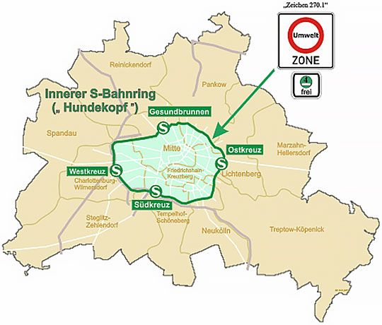
The low emission zone covers the centre of Berlin inside the S-Bahn ring. It has an area of approximately 88 km2. So, only 10 % of the total area of Berlin lay within the low emission zone. This area is particularly densely built-up. More than one million of the 3.7 million inhabitants of Berlin live here. Traffic signs (sign No. 270.1) at the approach roads indicate the low emission zone. These are located primarily at the bridges and underpasses of the S-Bahn railway. The graphic above shows the signs for the Berlin low emission zone. As the small additional sign indicates, only vehicles with a green sticker are allowed to drive.

You can use the map below to check which streets or postcodes are part of the low-emission zone:

  • Graphical representation of postcodes

    PDF-Document (523.0 kB)

  • Table of postcodes

    XLSX-Document (36.3 kB)

A number of roads within the S-Bahn ring are not part of the low-emission zone and remain freely accessible, allowing the low-emission zone to be avoided by vehicles without a green sticker without their having to make a lengthy detour. These are, in particular, the southern part of the city highway with the relevant access roads and Elsenbrücke across the Spree with its feeder roads. By the same token, one road located outside the inner S-Bahn ring – Kanzow-Strasse in Prenzlauer Berg – had to be included for traffic-related reasons. The following maps show the boundaries of the low-emission zone:

  • Map with the border of the low emission zone – complete map

    low resolution

    PDF-Document (2.0 MB)

  • Map with the border of the low emission zone – complete map

    high resolution

    PDF-Document (10.4 MB)

  • Map 1 – AS Kaiserdamm / Kaiserdammbrücke

    PDF-Document (1.5 MB)

  • Map 2 – AS Hohenzollerndamm / AS Schmargendorf

    PDF-Document (1.2 MB)

  • Map 3/4 – Heidelberger Platz / AS Detmolder Straße

    PDF-Document (282.2 kB)

  • Map 5/6 – Bundesplatz / AS Innsbrucker Platz

    PDF-Document (1.3 MB)

  • Map 7 – Elsenstraße / Elsenbrücke / S Ostkreuz

    PDF-Document (1.7 MB)

  • Map 8 – Gürtelstraße / S Frankfurter Allee

    PDF-Document (1.8 MB)

  • Map 9 – Kanzowstraße / S Prenzlauer Allee

    PDF-Document (638.9 kB)

  • Map 10 – Fennstraße / S Wedding

    PDF-Document (1.7 MB)

Map

BERLIN OPEN DATA

Service